
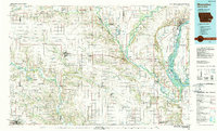
1984 Map of Muscatine
USGS Topo · Published 1985About this map
The Mississippi River and its expansive floodplain dominate the eastern edge of this mid-1980s survey, where industrial and agricultural life converge near Muscatine. The river's reach is marked by major navigation infrastructure including Lock & Dam No 16 and Lock & Dam No 17, while the fertile lowlands of Muscatine Island and Hog Island sit between the main channel and Muscatine Slough. Inland, the landscape is defined by the convergence of the Iowa River and Cedar River, with vast conservation areas like the Mark Twain National Wildlife Refuge and Klum Lake State Game Management Area preserving the riverine wetlands.
Find a feature on this map
163 named features on this map. Tap any name to fly to it.
Don’t see what you’re looking for? This feature index may not catch every label — zoom into the map to look around manually.
Map Details
Editions of this 1984 Muscatine Map
2 editions found
Other maps of this area

1890 · Durant
USGS Topo · 1:62,500

1891 · Oxford
USGS Topo · 1:62,500

1891 · Iowa City
USGS Topo · 1:62,500

1891 · Wilton Junction
USGS Topo · 1:62,500

1894 · Durant
USGS Topo · 1:62,500

1894 · Oxford
USGS Topo · 1:62,500
1894 · West Liberty
USGS Topo · 1:62,500

1901 · Rock Island
USGS Topo · 1:125,000

1901 · Stanwood
USGS Topo · 1:125,000

1903 · Fairfax
USGS Topo · 1:125,000