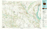
1984 Map of Muscatine
USGS Topo · Published 1989About this map
The Mississippi River and its major tributaries, including the Iowa River, Cedar River, and English River, define the landscape of this 1984 survey. The map details a sophisticated network of water and rail transport, anchored by the industrial hub of Muscatine and the regional center of Washington. The Chicago Rock Island and Pacific railroad lines are visible connecting smaller farming communities such as Columbus Junction, West Chester, and Kalona.
Find a feature on this map
142 named features on this map. Tap any name to fly to it.
Don’t see what you’re looking for? This feature index may not catch every label — zoom into the map to look around manually.
Map Details
Editions of this 1984 Muscatine Map
2 editions found
Other maps of this area

1890 · Durant
USGS Topo · 1:62,500

1891 · Oxford
USGS Topo · 1:62,500

1891 · Iowa City
USGS Topo · 1:62,500

1891 · Wilton Junction
USGS Topo · 1:62,500

1894 · Durant
USGS Topo · 1:62,500

1894 · Oxford
USGS Topo · 1:62,500

1894 · West Liberty
USGS Topo · 1:62,500

1901 · Rock Island
USGS Topo · 1:125,000

1901 · Stanwood
USGS Topo · 1:125,000

1903 · Fairfax
USGS Topo · 1:125,000