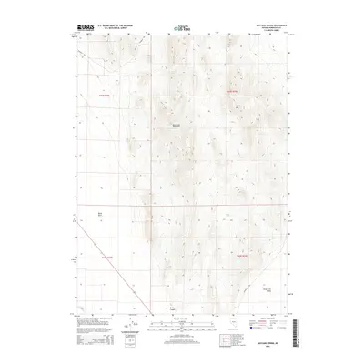
2015 Map of Mustang Spring
USGS Topo · Published 2015About this map
Bilk Creek Mountains dominate the central topography of this high-desert region, rising sharply above the surrounding basins. The landscape is defined by its vital water sources, including Mustang Spring, Mine Spring, and DeLong Spring, which historically served as critical points for travelers and livestock in this arid climate. The western edge of the map gives way to the expansive Black Rock Desert, while the eastern portion transitions into the Kings River Valley.
Find a feature on this map
15 named features on this map. Tap any name to fly to it.
Don’t see what you’re looking for? This feature index may not catch every label — zoom into the map to look around manually.
Map Details
Editions of this 2015 Mustang Spring Map
This is the sole edition of this map. No revisions or reprints were ever made.
Other maps of this area

1886 · Disaster
USGS Topo · 1:250,000

1893 · Disaster
USGS Topo · 1:250,000

1954 · Vya
USGS Topo · 1:250,000

1958 · Vya
USGS Topo · 1:250,000

1961 · Quinn River Crossing
USGS Topo · 1:62,500

1961 · Thacker Pass
USGS Topo · 1:62,500

1961 · Bottle Creek
USGS Topo · 1:62,500

1962 · Vya
USGS Topo · 1:250,000

1979 · Denio
USGS Topo · 1:100,000
1982 · Bottle Creek Slough NW
USGS Topo · 1:24,000