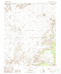
1988 Map of Mystery Valley
USGS Topo · Published 1988About this map
The Navajo Indian Reservation spans the border of Arizona and Utah in this late 1980s topographical study. The landscape is defined by the high elevations of Mitchell Mesa and Wetherill Mesa, where the terrain drops into the complex drainage of Horse Canyon and Mitchell Butte Wash. This area is particularly noted for its geological formations, including the Full Moon Arch and several other Natural Arches that mark the sandstone faces of the mesas. Human presence is indicated primarily by deep-desert infrastructure, including the Monument No 1 Tunnel, various corrals, and remote water sources such as Goulding Well. The map captures the intricate landforms of Mystery Valley, illustrating how the dry washes and prominent landmarks like Gray Whiskers and Mitchell Butte dominate this part of the Four Corners region.
Find a feature on this map
19 named features on this map. Tap any name to fly to it.
Don’t see what you’re looking for? This feature index may not catch every label — zoom into the map to look around manually.
Map Details
Editions of this 1988 Mystery Valley Map
This is the sole edition of this map. No revisions or reprints were ever made.
Other maps of this area

1883 · Marsh Pass
USGS Topo · 1:250,000

1886 · Henry Mountains
USGS Topo · 1:250,000

1892 · Marsh Pass
USGS Topo · 1:250,000

1892 · Henry Mountains
USGS Topo · 1:250,000

1952 · Clay Hills 4 SW
USGS Topo · 1:24,000

1952 · Clay Hills 3 SE
USGS Topo · 1:24,000

1952 · Agathla Peak 1 NW
USGS Topo · 1:24,000

1952 · Boot Mesa
USGS Topo · 1:62,500

1952 · Clay Hills 4 SE
USGS Topo · 1:24,000

1952 · Agathla Peak 1 NE
USGS Topo · 1:24,000