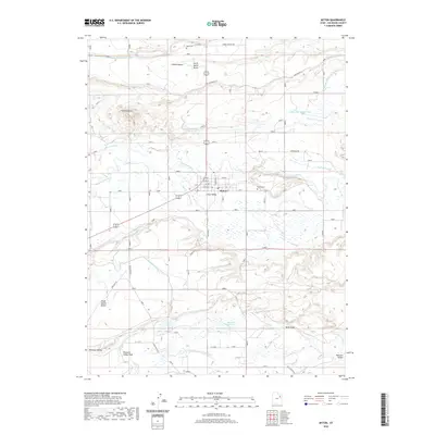
2020 Map of Myton
USGS Topo · Published 2020About this map
The Duchesne River and Lake Fork River converge in the Uinta Valley, defining the geographic character of this high-desert basin. The settlement of Myton serves as a central hub, surrounded by an intricate network of irrigation projects including the Myton Townsite Canal, New Hope Canal, and Riverdell Canal. These man-made waterways illustrate the historical effort to reclaim and cultivate the arid benches of Duchesne County, moving water from the river bottoms to agricultural lands like North Myton Bench and South Myton Bench. To the south, the landscape shifts toward the drainage of Pleasant Valley and the Hancock Reservoir, while local history is anchored by the Myton Cem and Ioka Cem. The grid of the Myton townsite, with streets like W Main St, contrasts with the winding paths of natural features like Cobble Hollow and Wells Draw.
Find a feature on this map
44 named features on this map. Tap any name to fly to it.
Don’t see what you’re looking for? This feature index may not catch every label — zoom into the map to look around manually.
Map Details
Editions of this 2020 Myton Map
This is the sole edition of this map. No revisions or reprints were ever made.
Other maps of this area

1885 · Ashley
USGS Topo · 1:250,000

1885 · Uinta
USGS Topo · 1:250,000

1917 · Vernal
USGS Topo · 1:125,000

1939 · Duchesne
USGS Topo · 1:125,000

1954 · Salt Lake City
USGS Topo · 1:250,000

1954 · Vernal
USGS Topo · 1:250,000

1958 · Vernal
USGS Topo · 1:250,000

1958 · Salt Lake City
USGS Topo · 1:250,000

1960 · Salt Lake City
USGS Topo · 1:250,000

1960 · Vernal
USGS Topo · 1:250,000