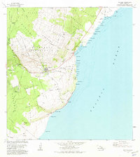
1981 Map of Naalehu
USGS Topo · Published 1981About this map
The southern coast of the Island of Hawaii is captured here in 1981, anchored by the settlements of Naalehu and Waiohinu. This landscape transitions from the volcanic slopes of the Waiohinu Reserve down to the dramatic Pacific coastline. The map records a complex human footprint, including Kiolakaa-Keaa Homesteads and Kaunamano Homesteads, alongside traditional cultural sites like Keeku Heiau near the shore. Transportation and infrastructure of the era are visible in the Kaalaiki Landing Strip and numerous Water Tanks scattered across the land divisions of Kaalaiki and Honuapo. Along the coast, Whittington Park sits near the former port area of Honuapo Bay, while several springs, including Portuguese Springs and Haao Springs, suggest the vital importance of water sources in this volcanic terrain. Significant landmarks like Puhuila Cave Ruins and Pali Pohina further emphasize the historical depth of the Kau District.
Find a feature on this map
83 named features on this map. Tap any name to fly to it.
Don’t see what you’re looking for? This feature index may not catch every label — zoom into the map to look around manually.
Map Details
Editions of this 1981 Naalehu Map
This is the sole edition of this map. No revisions or reprints were ever made.
Other maps of this area

1923 · Pahala
USGS Topo · 1:62,500

1924 · Kalae
USGS Topo · 1:62,500

1924 · Honuapo
USGS Topo · 1:62,500

1954 · Hawaii South
USGS Topo · 1:250,000

1959 · Hawaii South
USGS Topo · 1:250,000

1961 · Hawaii South
USGS Topo · 1:250,000

1962 · Hawaii South
USGS Topo · 1:250,000

1962 · Kahuku Ranch
USGS Topo · 1:24,000
1962 · Ka Lae
USGS Topo · 1:24,000
1962 · Naalehu
USGS Topo · 1:24,000