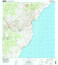
1995 Map of Naalehu
USGS Topo · Published 2000About this map
Naalehu and the nearby village of Waiohinu anchor this coastal landscape in the Ka'u District during the mid-1990s. The map illustrates a transition from the dense tropical canopy of the Ka'u Forest Reserve down to the dramatic volcanic coastline defined by the Pohina Pali and Maniania Pali cliffs. Settlement patterns are concentrated in the Kaunamano Homesteads and Kiolakaa-Kea'a Homesteads, reflecting the agricultural and residential history of the region. Evidence of local industry and infrastructure is visible at the Cinder Pit and the Ka'ala'iki Landing Strip. Along the shoreline, numerous traditional Hawaiian place names for small bays and points, such as Honu'apo Bay and Waikapuna Bay, highlight the enduring connection between the land and the Pacific. Public spaces like Waiohinu Park and Whittington Park mark established community hubs near the island's southern reaches.
Find a feature on this map
73 named features on this map. Tap any name to fly to it.
Don’t see what you’re looking for? This feature index may not catch every label — zoom into the map to look around manually.
Map Details
Editions of this 1995 Naalehu Map
This is the sole edition of this map. No revisions or reprints were ever made.
Other maps of this area

1923 · Pahala
USGS Topo · 1:62,500

1924 · Kalae
USGS Topo · 1:62,500

1924 · Honuapo
USGS Topo · 1:62,500

1954 · Hawaii South
USGS Topo · 1:250,000

1959 · Hawaii South
USGS Topo · 1:250,000

1961 · Hawaii South
USGS Topo · 1:250,000

1962 · Hawaii South
USGS Topo · 1:250,000

1962 · Kahuku Ranch
USGS Topo · 1:24,000
1962 · Ka Lae
USGS Topo · 1:24,000
1962 · Naalehu
USGS Topo · 1:24,000