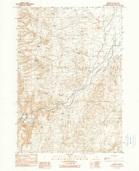
1990 Map of Namorf
USGS Topo · Published 1990About this map
The Malheur River cuts a sharp path through this high desert landscape, defining the character of the Harper Valley in Malheur County. This 1990 provisional survey documents a network of water management features essential for life in the arid basin, including numerous named stock tanks and reservoirs such as the Medlin Reservoir, Chicken Creek Reservoir, and Hollow Reservoir. The small settlement of Namorf sits along the river's edge, adjacent to a Gaging Sta and the Oregon Vale route. The terrain is marked by significant features like Hog Ridge and is dissected by seasonal drainages including Corbett Creek and Squaw Creek. This map reveals the intricate reliance on springs such as Tumbleweed Spring and Shaw Spring for livestock and local use, while the presence of a Landing Strip and various canals highlights the infrastructure required to navigate and cultivate this remote canyon country.
Find a feature on this map
33 named features on this map. Tap any name to fly to it.
Don’t see what you’re looking for? This feature index may not catch every label — zoom into the map to look around manually.
Map Details
Editions of this 1990 Namorf Map
This is the sole edition of this map. No revisions or reprints were ever made.
Other maps of this area

1955 · Boise
USGS Topo · 1:250,000

1958 · Boise
USGS Topo · 1:250,000

1962 · Boise
USGS Topo · 1:250,000

1966 · Harper
USGS Topo · 1:62,500

1966 · Westfall Butte
USGS Topo · 1:62,500

1972 · Tims Peak
USGS Topo · 1:24,000

1972 · Avery Creek
USGS Topo · 1:24,000
1972 · Keeney Ridge
USGS Topo · 1:24,000
1990 · South Mountain
USGS Topo · 1:24,000
1990 · Westfall
USGS Topo · 1:24,000