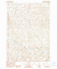
1990 Map of South Mountain
USGS Topo · Published 1990About this map
South Mountain dominates this portion of Malheur County, where the high desert landscape is defined by its vital water management systems and remote livestock ranching. The Malheur River cuts through the southern terrain, flanked by grazing lands like Hinkle Ranch and Perry Ranch. This 1990 provisional update shows a network of upland water sources essential for cattle and wildlife, including South Mtn Reservoir, Alfred Reservoir, and Tub Springs Reservoir. Narrow drainage systems like Black Canyon and Simmons Gulch illustrate the complex topography surrounding Hog Ridge. Scattered springs such as Coyne Spring and Gold Spring provide small, reliable water points in a territory where the South Fork Cottonwood Creek and Hog Creek shape the descent from the mountain peaks toward the river valley.
Find a feature on this map
24 named features on this map. Tap any name to fly to it.
Don’t see what you’re looking for? This feature index may not catch every label — zoom into the map to look around manually.
Map Details
Editions of this 1990 South Mountain Map
This is the sole edition of this map. No revisions or reprints were ever made.
Other maps of this area

1955 · Boise
USGS Topo · 1:250,000

1958 · Boise
USGS Topo · 1:250,000

1962 · Boise
USGS Topo · 1:250,000

1966 · Harper
USGS Topo · 1:62,500

1966 · Westfall Butte
USGS Topo · 1:62,500

1972 · Tims Peak
USGS Topo · 1:24,000

1972 · Avery Creek
USGS Topo · 1:24,000
1972 · Monument Peak
USGS Topo · 1:24,000
1990 · Westfall
USGS Topo · 1:24,000
1990 · Namorf
USGS Topo · 1:24,000