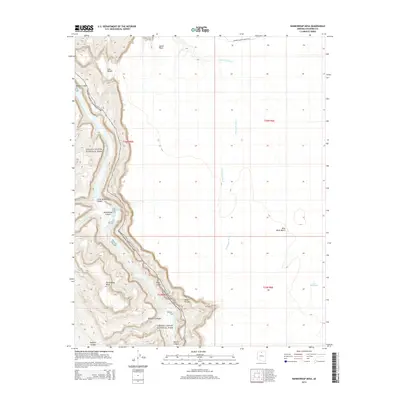
2014 Map of Nankoweap Mesa
USGS Topo · Published 2014About this map
The Colorado River carves a deep path through Grand Canyon National Park in this northern Arizona survey, defining a landscape of profound verticality and desert geography. High plateau features like Nankoweap Mesa and Blue Moon Bench rise above the river's eastern banks, while intricate drainages such as Little Nankoweap Canyon and Kwagunt Canyon demonstrate the erosive forces of seasonal water. Landmarks such as Gray Castle and Desert Facade represent the striking geological formations that line the canyon walls. Away from the river, the terrain flattens into expansive washes, notably Tatahoysa Wash, which carries runoff from the northeast toward the river. Human activity is marked primarily by the Marble Canyon Damsite Rd, which terminates near the rim of Marble Canyon, hinting at mid-century engineering interests in this remote stretch of the Colorado.
Find a feature on this map
22 named features on this map. Tap any name to fly to it.
Don’t see what you’re looking for? This feature index may not catch every label — zoom into the map to look around manually.
Map Details
Editions of this 2014 Nankoweap Mesa Map
This is the sole edition of this map. No revisions or reprints were ever made.
Other maps of this area

1886 · Echo Cliffs
USGS Topo · 1:250,000

1891 · Echo Cliffs
USGS Topo · 1:250,000

1907 · Vishnu
USGS Topo · 1:48,000

1954 · Nankoweap
USGS Topo · 1:62,500

1954 · Shinumo Altar
USGS Topo · 1:62,500

1955 · Blue Spring
USGS Topo · 1:62,500

1956 · Marble Canyon
USGS Topo · 1:250,000

1959 · Marble Canyon
USGS Topo · 1:250,000

1961 · Marble Canyon
USGS Topo · 1:250,000
1962 · Vishnu Temple
USGS Topo · 1:62,500