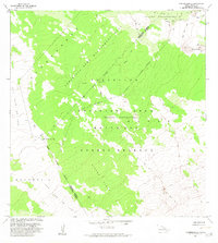
1982 Map of Naohueleelua
USGS Topo · Published 1982About this map
The Lava Flow of 1859 dominates this high-elevation landscape on the Island of Hawaii, marking a distinct boundary across the North Kona and Hamakua District lines. This 1982 revision illustrates the intersection of conservation and military use, where the Pohakuloa Game Management Area meets the Pohakuloa Training Area (Military Reservation). Isolated pockets of vegetation, or kipukas, emerge from the volcanic fields, including Kipuka Kalawamauna and Kipuka Alala, providing vital islands of habitat amidst the basalt. Near the western edge, the settlement of Naohueleelua sits at the terminus of a series of Jeep Trails, while the slopes of Mauna Loa rise to the south. The map provides a detailed view of the Forest Reserve and volcanic features such as Na Puu Kulua, highlighting the specialized land management required in this ecologically unique environment.
Find a feature on this map
14 named features on this map. Tap any name to fly to it.
Don’t see what you’re looking for? This feature index may not catch every label — zoom into the map to look around manually.
Map Details
Editions of this 1982 Naohueleelua Map
This is the sole edition of this map. No revisions or reprints were ever made.
Other maps of this area

1927 · Kaohe
USGS Topo · 1:62,500

1928 · Puako
USGS Topo · 1:62,500

1928 · Kailua
USGS Topo · 1:62,500

1930 · Kaohe
USGS Topo · 1:62,500

1954 · Hawaii North
USGS Topo · 1:250,000

1956 · Puu Koli
USGS Topo · 1:24,000

1956 · Keamuku
USGS Topo · 1:24,000

1956 · Puu O Uo
USGS Topo · 1:24,000
1956 · Ahumoa
USGS Topo · 1:24,000
1956 · Kokoolau
USGS Topo · 1:24,000