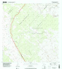
1993 Map of Naohuleelua
USGS Topo · Published 2001About this map
The Lava Flow of 1859 dominates the western landscape of this high-elevation region, cutting a distinct path through Keauhou 2 and past the settlement of Na'ohule'elua. The map illustrates a transitional environment where conservation and military utility intersect, partitioned by the North Kona and Hamakua District boundary. This area is characterized by vast management tracts, including the Pu'uanahulu Game Management Area and the Pohakuloa Training Area, which occupies a significant portion of the eastern volcanic terrain.
Find a feature on this map
18 named features on this map. Tap any name to fly to it.
Don’t see what you’re looking for? This feature index may not catch every label — zoom into the map to look around manually.
Map Details
Editions of this 1993 Naohuleelua Map
This is the sole edition of this map. No revisions or reprints were ever made.
Other maps of this area

1927 · Kaohe
USGS Topo · 1:62,500

1928 · Puako
USGS Topo · 1:62,500

1928 · Kailua
USGS Topo · 1:62,500

1930 · Kaohe
USGS Topo · 1:62,500

1954 · Hawaii North
USGS Topo · 1:250,000

1956 · Puu Koli
USGS Topo · 1:24,000

1956 · Keamuku
USGS Topo · 1:24,000

1956 · Puu O Uo
USGS Topo · 1:24,000
1956 · Ahumoa
USGS Topo · 1:24,000
1956 · Kokoolau
USGS Topo · 1:24,000