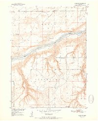
1951 Map of Naper SW
USGS Topo · Published 1951About this map
The Niobrara River winds across this north-central Nebraska landscape, carving a distinct valley between the Basin and Cleveland regions. This mid-century survey documents a rural ranching economy where property boundaries often follow natural watercourses like Otter Creek and Beaver Creek. The map provides specific locations for livestock operations such as Davis Ranch and Tienken Ranch, which served as local anchors in this sparsely populated territory.
Find a feature on this map
16 named features on this map. Tap any name to fly to it.
Don’t see what you’re looking for? This feature index may not catch every label — zoom into the map to look around manually.
Map Details
Editions of this 1951 Naper SW Map
2 editions found
Other maps of this area

1950 · Mariaville
USGS Topo · 1:24,000

1951 · Naper
USGS Topo · 1:24,000

1951 · Dustin
USGS Topo · 1:24,000

1951 · Naper SW
USGS Topo · 1:24,000

1954 · Stuart NW
USGS Topo · 1:24,000

1954 · Newport NE
USGS Topo · 1:24,000

1954 · Stuart NE
USGS Topo · 1:24,000

1955 · O'Neill
USGS Topo · 1:250,000

1959 · O'Neill
USGS Topo · 1:250,000
1964 · Jamison
USGS Topo · 1:24,000