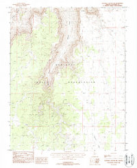
1988 Map of National Canyon SW
USGS Topo · Published 1988About this map
Hualapai Indian Reservation lands dominate this high-desert plateau, where the landscape is defined by the dramatic descent into National Canyon and Mohawk Canyon. This 1988 provisional edition captures a region where survival is tied to the management of scarce water resources, as evidenced by features like the Catchment Water Tank and a lone Corral. The intricate contour lines reveal the complex drainage systems of the Sandstone Wash, illustrating the rugged erosional patterns that characterize the Coconino County backcountry. The map serves as a detailed record of the township and range boundaries, including Townships 31 and 32 North, providing a precise look at the geographical layout of this remote tribal territory during the late 20th century.
Find a feature on this map
12 named features on this map. Tap any name to fly to it.
Don’t see what you’re looking for? This feature index may not catch every label — zoom into the map to look around manually.
Map Details
Editions of this 1988 National Canyon SW Map
This is the sole edition of this map. No revisions or reprints were ever made.
Other maps of this area

1886 · Diamond Creek
USGS Topo · 1:250,000

1886 · Mt. Trumbull
USGS Topo · 1:250,000

1886 · Chino
USGS Topo · 1:250,000

1886 · Kaibab
USGS Topo · 1:250,000

1891 · Chino
USGS Topo · 1:250,000

1892 · Diamond Creek
USGS Topo · 1:250,000

1892 · Mt. Trumbull
USGS Topo · 1:250,000

1948 · Williams
USGS Topo · 1:250,000

1953 · Grand Canyon
USGS Topo · 1:250,000

1954 · Williams
USGS Topo · 1:250,000