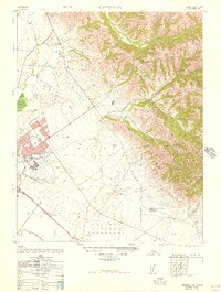
1948 Map of Natividad
USGS Topo · Published 1948About this map
The Gabilan Range rises sharply above the fertile floor of the Salinas Valley on this post-war military-to-civilian conversion map. The landscape is a mix of agricultural tracts and military decommissioning, notably featuring the Salinas Air Base (Abandoned) and the U S Army Radio Station (Abandoned). Historically significant land grants are clearly delineated, including La Natividad, Sausal, and El Alisal (Bernal), reflecting the region's Spanish and Mexican heritage. Local commerce and education are represented by the presence of Hartnell College and the Salinas Municipal Airport, while the Southern Pacific railroad and the Old Stage Road suggest the layers of transportation history connecting the settlements of Natividad and Alisal. Water drainage follows the natural contours through Gabilan Creek and Alisal Slough, supporting the intensive valley floor land use.
Find a feature on this map
22 named features on this map. Tap any name to fly to it.
Don’t see what you’re looking for? This feature index may not catch every label — zoom into the map to look around manually.
Map Details
Editions of this 1948 Natividad Map
This is the sole edition of this map. No revisions or reprints were ever made.
Other maps of this area

1910 · Gonzales
USGS Topo · 1:31,680

1910 · Salinas
USGS Topo · 1:31,680

1912 · Salinas
USGS Topo · 1:62,500

1915 · San Juan Bautista
USGS Topo · 1:48,000

1917 · San Juan Bautista
USGS Topo · 1:62,500

1919 · Hollister
USGS Topo · 1:48,000

1921 · Gonzales
USGS Topo · 1:62,500

1921 · Hollister
USGS Topo · 1:62,500

1923 · Hollister
USGS Topo · 1:62,500

1939 · San Juan Bautista
USGS Topo · 1:62,500