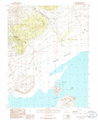
1986 Map of Negit Island
USGS Topo · Published 1986About this map
Negit Island and Paoha Island rise from the waters of Mono Lake in this mid-1980s provisional study of the Mono Basin. The map details a landscape defined by volcanic landforms and industrial extraction, most notably at Black Point along the northern shore. The terrain is marked by numerous mineral exploratory efforts, with several labeled Prospects, a Mine Shaft, and a Prospect Mine Shaft scattered through the high ground of Rancheria Gulch and Bridgeport Canyon.
Find a feature on this map
21 named features on this map. Tap any name to fly to it.
Don’t see what you’re looking for? This feature index may not catch every label — zoom into the map to look around manually.
Map Details
Editions of this 1986 Negit Island Map
This is the sole edition of this map. No revisions or reprints were ever made.
Other maps of this area

1901 · Mt. Lyell
USGS Topo · 1:125,000

1909 · Hawthorne
USGS Topo · 1:250,000

1909 · Bridgeport
USGS Topo · 1:125,000

1911 · Bridgeport
USGS Topo · 1:125,000

1911 · Hawthorne
USGS Topo · 1:250,000

1914 · Mt. Morrison
USGS Topo · 1:125,000

1915 · Hawthorne
USGS Topo · 1:250,000

1920 · Bridgeport
USGS Topo · 1:125,000

1947 · Mariposa
USGS Topo · 1:250,000

1948 · Walker Lake
USGS Topo · 1:250,000