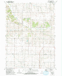
1992 Map of Nekoma
USGS Topo · Published 1992About this map
Nekoma serves as the central hub of this agricultural landscape in northwestern Illinois, situated at a junction where the legacy of rail transport remains visible. An Old Railroad Grade cuts across the center of the sheet, tracing a path through the townships of Weller and Clover. This corridor suggests the historical importance of rail-to-farm connections in the late 20th century, even as physical tracks were replaced by grades. To the north, the South Edwards River is bordered by a levee system, indicating the active water management required for the surrounding lowlands.
Find a feature on this map
18 named features on this map. Tap any name to fly to it.
Don’t see what you’re looking for? This feature index may not catch every label — zoom into the map to look around manually.
Map Details
Editions of this 1992 Nekoma Map
This is the sole edition of this map. No revisions or reprints were ever made.
Other maps of this area

1931 · Galva
USGS Topo · 1:48,000

1934 · Geneseo
USGS Topo · 1:62,500

1937 · Orion
USGS Topo · 1:62,500

1940 · Galva
USGS Topo · 1:62,500

1944 · Galva
USGS Topo · 1:62,500

1947 · Woodhull
USGS Topo · 1:62,500

1953 · Nekoma
USGS Topo · 1:24,000

1953 · Woodhull
USGS Topo · 1:24,000

1953 · German Corner
USGS Topo · 1:24,000
1953 · Andover
USGS Topo · 1:24,000