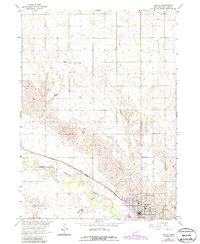
1963 Map of Neligh
USGS Topo · Published 1986About this map
Neligh serves as the focal point of this Nebraska landscape, situated where the Chicago and North Western rail line parallels the sweeping course of the Elkhorn River. The town's grid is detailed with landmarks such as a Water Tank and High Sch, while the surrounding countryside is defined by the drainage of Antelope Creek and Hail Creek. This 1960s survey provides a clear view of the rural educational infrastructure of the period, noting several outlying schoolhouses including School No 38, School No 88, and School No 107. To the west, the Red-Wing State Wildlife Management Area occupies the river bottomlands, illustrating the conservation of Nebraska's riparian habitats. Genealogists will find the Laurel Hill Cem on the eastern edge of the community, a key site for local history research.
Find a feature on this map
15 named features on this map. Tap any name to fly to it.
Don’t see what you’re looking for? This feature index may not catch every label — zoom into the map to look around manually.
Map Details
Editions of this 1963 Neligh Map
2 editions found
Other maps of this area

1955 · Sioux City
USGS Topo · 1:250,000

1955 · O'Neill
USGS Topo · 1:250,000

1958 · Sioux City
USGS Topo · 1:250,000

1959 · O'Neill
USGS Topo · 1:250,000

1959 · Sioux City
USGS Topo · 1:250,000

1963 · Neligh
USGS Topo · 1:24,000

1963 · Neligh SE
USGS Topo · 1:24,000
1963 · Oakdale
USGS Topo · 1:24,000

1963 · Brunswick
USGS Topo · 1:24,000

1963 · Neligh SW
USGS Topo · 1:24,000