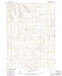
1963 Map of Neligh SW
USGS Topo · Published 1986About this map
Clearwater Creek and its southern tributaries, Rabbit Creek and Snake Creek, define the topography of this Antelope County landscape. Originally surveyed in the early 1960s with updates added in the 1980s, the map illustrates a rural Nebraska territory organized by the section lines of the Public Land Survey System. Human footprints are sparse but significant for local history, including the Lutheran Cem in the northwest and the Edwards Landing Strip to the southwest. The presence of a Substation and a network of unimproved roads indicates the slow expansion of infrastructure across the rolling plains. To the east, Antelope Creek cuts through the terrain, highlighting the importance of natural drainage in this agricultural region during the mid-to-late 20th century.
Find a feature on this map
8 named features on this map. Tap any name to fly to it.
Don’t see what you’re looking for? This feature index may not catch every label — zoom into the map to look around manually.
Map Details
Editions of this 1963 Neligh SW Map
3 editions found
Other maps of this area

1955 · Broken Bow
USGS Topo · 1:250,000

1955 · O'Neill
USGS Topo · 1:250,000

1956 · Broken Bow
USGS Topo · 1:250,000

1959 · O'Neill
USGS Topo · 1:250,000

1960 · Spalding 2 NE
USGS Topo · 1:24,000

1963 · Neligh
USGS Topo · 1:24,000

1963 · Neligh SE
USGS Topo · 1:24,000

1963 · Deloit
USGS Topo · 1:24,000

1963 · Neligh SW
USGS Topo · 1:24,000

1963 · Elgin NW
USGS Topo · 1:24,000