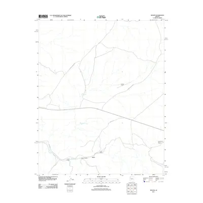
2011 Map of Nelson
USGS Topo · Published 2011About this map
Nelson occupies a strategic position in the southwestern corner of this survey, where it is defined by the convergence of the Truxton Wash and Nelson Canyon. The landscape is etched by seasonal water sources and deep incisions in the earth, most notably Faught Canyon to the west. This area serves as a transit corridor for both aviation and overland travel, housing both the Hualapai Airport and the Grand Canyon Caverns Airport. The infrastructure reflects the high-desert environment's reliance on managed water, marked by sites like Limestone Tank and Bull-Pasture Tank. Local history and genealogy are centered around the Nelson Cemetery, located just north of the primary settlement. The road network, including the Hualapai Reservation Rd and Indian Rte 19, indicates the importance of these routes for connecting the tribal lands and remote outposts to the wider region.
Find a feature on this map
13 named features on this map. Tap any name to fly to it.
Don’t see what you’re looking for? This feature index may not catch every label — zoom into the map to look around manually.
Map Details
Editions of this 2011 Nelson Map
This is the sole edition of this map. No revisions or reprints were ever made.
Other maps of this area

1886 · Diamond Creek
USGS Topo · 1:250,000

1892 · Diamond Creek
USGS Topo · 1:250,000

1948 · Williams
USGS Topo · 1:250,000

1954 · Williams
USGS Topo · 1:250,000

1956 · Williams
USGS Topo · 1:250,000

1960 · Williams
USGS Topo · 1:250,000

1961 · Williams
USGS Topo · 1:250,000

1967 · Peach Springs
USGS Topo · 1:24,000
1967 · Peach Springs Canyon
USGS Topo · 1:24,000
1967 · Peach Springs NE
USGS Topo · 1:24,000