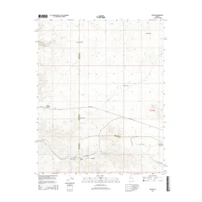
2014 Map of Nelson
USGS Topo · Published 2014About this map
Historic US-66 cuts across this high-desert landscape, tracing a legendary corridor through the intersection of Mohave, Coconino, and Yavapai Counties. The small settlement of Nelson serves as a central landmark, situated near the head of Nelson Canyon and Faught Canyon. This area is defined by its transit history and arid-land water management, with features like Limestone Tank and Bull Pasture Tank providing essential water sources in a region of dramatic elevation changes and dry washes like Truxton Wash.
Find a feature on this map
27 named features on this map. Tap any name to fly to it.
Don’t see what you’re looking for? This feature index may not catch every label — zoom into the map to look around manually.
Map Details
Editions of this 2014 Nelson Map
This is the sole edition of this map. No revisions or reprints were ever made.
Other maps of this area

1886 · Diamond Creek
USGS Topo · 1:250,000

1892 · Diamond Creek
USGS Topo · 1:250,000

1948 · Williams
USGS Topo · 1:250,000

1954 · Williams
USGS Topo · 1:250,000

1956 · Williams
USGS Topo · 1:250,000

1960 · Williams
USGS Topo · 1:250,000

1961 · Williams
USGS Topo · 1:250,000

1967 · Peach Springs
USGS Topo · 1:24,000
1967 · Peach Springs Canyon
USGS Topo · 1:24,000
1967 · Peach Springs NE
USGS Topo · 1:24,000