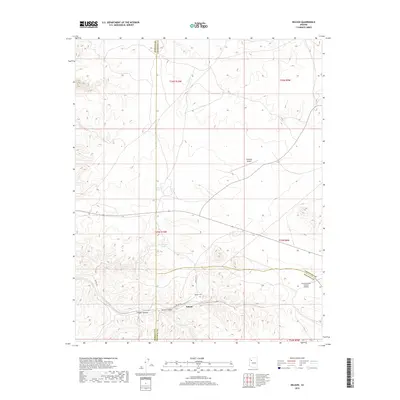
2018 Map of Nelson
USGS Topo · Published 2018About this map
Nelson occupies a central position in this high-desert landscape, situated where the terrain transitions toward the dramatic depths of Nelson Canyon and Faught Canyon. The settlement is served by a localized road network including Nelson Rd and Indian Rte 19, reflecting the area's role as a point of transit and habitation within Yavapai County. Local history is anchored at the Nelson Cem, providing a focal point for genealogical interest in this part of Arizona.
Find a feature on this map
19 named features on this map. Tap any name to fly to it.
Don’t see what you’re looking for? This feature index may not catch every label — zoom into the map to look around manually.
Map Details
Editions of this 2018 Nelson Map
This is the sole edition of this map. No revisions or reprints were ever made.
Other maps of this area

1886 · Diamond Creek
USGS Topo · 1:250,000

1892 · Diamond Creek
USGS Topo · 1:250,000

1948 · Williams
USGS Topo · 1:250,000

1954 · Williams
USGS Topo · 1:250,000

1956 · Williams
USGS Topo · 1:250,000

1960 · Williams
USGS Topo · 1:250,000

1961 · Williams
USGS Topo · 1:250,000

1967 · Peach Springs
USGS Topo · 1:24,000
1967 · Peach Springs Canyon
USGS Topo · 1:24,000
1967 · Peach Springs NE
USGS Topo · 1:24,000