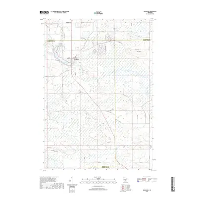
2018 Map of Neshkoro
USGS Topo · Published 2018About this map
The White River and Mecan River define this corner of Central Wisconsin where Waushara, Marquette, and Green Lake counties converge. The village of Neshkoro is the primary settlement, centered near the Neshkoro Mill Pond and marked by several community landmarks including the Zion Evangelical Lutheran Cem and Neshkoro Village Cem. This area represents a classic rural Wisconsin landscape of the early 21st century, where agricultural land is interspersed with significant wetland systems along Lunch Cr and Black Cr. To the north, the small settlement of Bannerman sits near the upper reaches of the White River valley. The presence of numerous historical burial grounds like the Germania Cem and Saint Peter Cem underscores the area's deep-rooted heritage, while the prominent Pine Bluff provides a notable elevation point overlooking the surrounding marshlands and river corridors.
Find a feature on this map
74 named features on this map. Tap any name to fly to it.
Don’t see what you’re looking for? This feature index may not catch every label — zoom into the map to look around manually.
Map Details
Editions of this 2018 Neshkoro Map
This is the sole edition of this map. No revisions or reprints were ever made.
Other maps of this area

1915 · Neshkoro
USGS Topo · 1:48,000

1918 · Neshkoro
USGS Topo · 1:62,500

1955 · Green Bay
USGS Topo · 1:250,000

1957 · Madison
USGS Topo · 1:250,000

1959 · Wautoma
USGS Topo · 1:48,000

1960 · Madison
USGS Topo · 1:250,000

1961 · Redgranite
USGS Topo · 1:62,500

1961 · Montello
USGS Topo · 1:62,500
1961 · Redgranite
USGS Topo · 1:24,000

1961 · Spring Lake
USGS Topo · 1:24,000