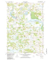
1984 Map of Neshkoro
USGS Topo · Published 1984About this map
The White River and Mecan River define the topography of this portion of Marquette and Waushara Counties, feeding into a landscape of marshes and controlled waters. The Neshkoro Mill Pond sits at the heart of the village of Neshkoro, where the Chicago and North Western tracks historically influenced the local economy. Much of the eastern portion of the sheet is occupied by the White River Marsh State Wildlife Area, reflecting the region's preservation of wetland habitats alongside rural agricultural land.
Find a feature on this map
44 named features on this map. Tap any name to fly to it.
Don’t see what you’re looking for? This feature index may not catch every label — zoom into the map to look around manually.
Map Details
Editions of this 1984 Neshkoro Map
This is the sole edition of this map. No revisions or reprints were ever made.
Other maps of this area

1915 · Neshkoro
USGS Topo · 1:48,000

1918 · Neshkoro
USGS Topo · 1:62,500

1955 · Green Bay
USGS Topo · 1:250,000

1957 · Madison
USGS Topo · 1:250,000

1959 · Wautoma
USGS Topo · 1:48,000

1960 · Madison
USGS Topo · 1:250,000

1961 · Redgranite
USGS Topo · 1:62,500

1961 · Montello
USGS Topo · 1:62,500
1961 · Redgranite
USGS Topo · 1:24,000

1961 · Spring Lake
USGS Topo · 1:24,000