
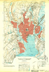
1943 Map of New Haven
USGS Topo · Published 1947About this map
Yale University serves as a central anchor for the urban core in this mid-century survey, with the massive Yale Bowl and Walter Camp Field defining the western athletic district. The landscape is deeply shaped by its natural topography and early infrastructure, from the dramatic West Rock Ridge in the north to the industrial harbor facilities at City Pt. The city's growth is framed by major corridors like the Edgwood Parkway and the New York New Haven and Hartford railroad, which facilitated the expansion of neighborhoods like Westville and Fair Haven. Along the shoreline of Long Island Sound, the map details a recreational and maritime economy, featuring the amusement hub at Savin Rock, the Sandy Point Lighthouse, and the military history of Fort Wooster. Large cemetery complexes, including St Lawrence Cemetery and Evergreen Cemetery, provide significant data for genealogists tracing local family history during this era of peak industrial activity.
Find a feature on this map
83 named features on this map. Tap any name to fly to it.
Don’t see what you’re looking for? This feature index may not catch every label — zoom into the map to look around manually.
Map Details
Editions of this 1943 New Haven Map
2 editions found
Other maps of this area

1889 · Derby
USGS Topo · 1:62,500

1891 · Bridgeport
USGS Topo · 1:62,500

1891 · Derby
USGS Topo · 1:62,500

1892 · New Haven
USGS Topo · 1:62,500

1893 · Bridgeport
USGS Topo · 1:62,500

1893 · Derby
USGS Topo · 1:62,500

1920 · Bridgeport
USGS Topo · 1:62,500

1921 · New Haven
USGS Topo · 1:62,500

1943 · Naugatuck
USGS Topo · 1:31,680

1947 · Hartford
USGS Topo · 1:250,000