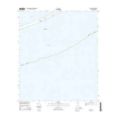
2015 Map of New Inlet
USGS Topo · Published 2015About this map
Saint George Island and Little Saint George Island dominate this coastal survey, separated by the narrow passage of Government Cut. These barrier islands buffer Apalachicola Bay from the open waters of the Gulf of Mexico, forming a critical physical boundary along the Florida panhandle. The map captures the delicate shoreline at New Inlet, where the shifting sands and tidal forces of the gulf meet the sound. While much of the terrain remains undeveloped, the inclusion of Leisure Ln indicates localized infrastructure on the eastern portion of Saint George Island. This document provides a precise record of the land-water interface and the navigable channels essential for maritime access to the bay during the early 21st century.
Find a feature on this map
9 named features on this map. Tap any name to fly to it.
Don’t see what you’re looking for? This feature index may not catch every label — zoom into the map to look around manually.
Map Details
Editions of this 2015 New Inlet Map
This is the sole edition of this map. No revisions or reprints were ever made.
Other maps of this area

1943 · West Pass
USGS Topo · 1:31,680

1943 · Apalachicola
USGS Topo · 1:31,680

1944 · Apalachicola
USGS Topo · 1:24,000

1945 · Cape St. George
USGS Topo · 1:31,680

1949 · Apalachicola
USGS Topo · 1:250,000

1950 · Goose Island
USGS Topo · 1:31,680
1950 · New Inlet
USGS Topo · 1:31,680

1957 · Apalachicola
USGS Topo · 1:250,000

1959 · Apalachicola
USGS Topo · 1:250,000
1960 · Apalachicola
USGS Topo · 1:250,000