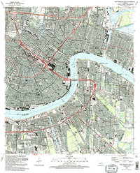
1992 Map of New Orleans East
USGS Topo · Published 1992About this map
The Mississippi River defines the geography of this 1990s-era study, sweeping through the Gouldsboro Bend and separating the historic Vieux Carre from the riverfront communities of Algiers and McDonoghville. The map illustrates the dense urban fabric of New Orleans, where landmarks like the Superdome and the Fairgrounds Race Track stand alongside vital infrastructure such as the Inner Harbor Navigation Canal and the Greater New Orleans Bridge.
Find a feature on this map
65 named features on this map. Tap any name to fly to it.
Don’t see what you’re looking for? This feature index may not catch every label — zoom into the map to look around manually.
Map Details
Editions of this 1992 New Orleans East Map
This is the sole edition of this map. No revisions or reprints were ever made.
Other maps of this area

1891 · Spanish Fort
USGS Topo · 1:62,500

1891 · New Orleans
USGS Topo · 1:62,500

1892 · Chef Menteur
USGS Topo · 1:62,500

1892 · St. Bernard
USGS Topo · 1:62,500

1932 · New Orleans NE
USGS Topo · 1:31,680

1932 · New Orleans NW
USGS Topo · 1:31,680

1932 · New Orleans SE
USGS Topo · 1:31,680

1932 · New Orleans SW
USGS Topo · 1:31,680

1936 · Chef Menteur
USGS Topo · 1:62,500

1936 · Spanish Fort
USGS Topo · 1:62,500