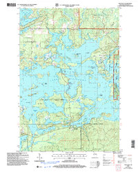
2005 Map of New Post
USGS Topo · Published 2006About this map
The New Post settlement, marked with its benchmark elevation, serves as the primary residential hub in this corner of Sawyer County. This landscape is defined by the expansive and complex waters of Chippewa River backwaters, encompassing numerous islands like Scott Island and Birch Island. Large portions of the territory are managed as the Chequamegon-Nicolet National Forest or fall within the Lac Courte Oreilles Indian Reservation Boundary.
Find a feature on this map
68 named features on this map. Tap any name to fly to it.
Don’t see what you’re looking for? This feature index may not catch every label — zoom into the map to look around manually.
Map Details
Editions of this 2005 New Post Map
This is the sole edition of this map. No revisions or reprints were ever made.
Other maps of this area

1943 · Namekagon Lake
USGS Topo · 1:48,000

1944 · Couderay
USGS Topo · 1:48,000

1944 · Radisson
USGS Topo · 1:48,000

1944 · Hayward
USGS Topo · 1:48,000

1945 · Namekagon Lake
USGS Topo · 1:48,000

1948 · Couderay
USGS Topo · 1:48,000

1949 · Radisson
USGS Topo · 1:48,000

1953 · Ashland
USGS Topo · 1:250,000

1953 · Rice Lake
USGS Topo · 1:250,000

1958 · Ashland
USGS Topo · 1:250,000