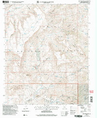
2004 Map of New River Mesa
USGS Topo · Published 2006About this map
Tonto National Forest land dominates this high-desert landscape north of Cave Creek, where the mining history of Maricopa County remains visible through sites like the Phoenix Mine and Maricopa Mine. The terrain is defined by the massive plateau of New River Mesa and the prominent heights of Elephant Mountain and Sugarloaf Mountain. Water is a scarce and vital resource in this environment, represented by a network of seasonal catchments such as Lopez Tank, Reed Tank, and New River Mesa Tank.
Find a feature on this map
73 named features on this map. Tap any name to fly to it.
Don’t see what you’re looking for? This feature index may not catch every label — zoom into the map to look around manually.
Map Details
Editions of this 2004 New River Mesa Map
This is the sole edition of this map. No revisions or reprints were ever made.
Other maps of this area

1887 · Verde
USGS Topo · 1:250,000

1887 · Prescott
USGS Topo · 1:250,000

1892 · Verde
USGS Topo · 1:250,000

1892 · Prescott
USGS Topo · 1:250,000

1903 · Bradshaw Mountains
USGS Topo · 1:125,000

1929 · Turret Peak
USGS Topo · 1:125,000

1930 · Cave Creek
USGS Topo · 1:125,000

1933 · Turret Peak
USGS Topo · 1:125,000

1939 · Cave Creek
USGS Topo · 1:125,000

1947 · Bumblebee
USGS Topo · 1:62,500