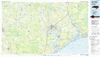
1986 Map of New River
USGS Topo · Published 1986About this map
Camp Lejeune Military Reservation dominates the coastal landscape of Onslow County in this mid-1980s survey, a time when the base and the city of Jacksonville served as the primary hubs for the region's growth. The map illustrates a complex network of coastal features, from the New River Inlet to the protected marshlands of Stump Sound and Bogue Sound. Inward from the Atlantic, the terrain transitions into significant conservation areas and managed timberlands, including the Angola Bay State Game Land and the Holly Shelter State Game Land.
Find a feature on this map
169 named features on this map. Tap any name to fly to it.
Don’t see what you’re looking for? This feature index may not catch every label — zoom into the map to look around manually.
Map Details
Editions of this 1986 New River Map
This is the sole edition of this map. No revisions or reprints were ever made.
Other maps of this area

1901 · New Bern
USGS Topo · 1:62,500

1903 · New Bern
USGS Topo · 1:62,500

1903 · Trent River
USGS Topo · 1:62,500

1904 · Trent River
USGS Topo · 1:62,500

1942 · Spicer Bay
USGS Topo · 1:62,500

1942 · Topsail
USGS Topo · 1:62,500

1942 · Burgaw
USGS Topo · 1:62,500

1942 · Maysville
USGS Topo · 1:62,500

1942 · Swansboro
USGS Topo · 1:62,500

1943 · Jacksonville
USGS Topo · 1:62,500