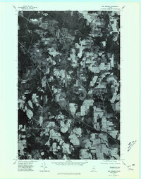
1975 Map of New Sweden
USGS Topo · Published 1981About this map
The town of New Sweden and its agricultural surroundings are captured in this 1975 orthophotomap, showing the distinctive land-use patterns of this Swedish colony in northern Maine. The map detail highlights the settlement at New Sweden Station and the outlying community of Acadia, where small farm clearings give way to dense forest. This aerial-based survey documents the rural character of the region before modern development, tracing the winding paths of the Little Madawaska River and Caribou Stream. Unlike traditional topographic maps, this orthophotoquad provides a direct visual record of the 1970s landscape, illustrating the precise boundaries of potato fields and woodlots that defined the local economy. From the village center of North Lyndon to the rail corridor near Barretts, the map serves as a primary source for understanding the spatial organization of these historic Aroostook County settlements.
Find a feature on this map
9 named features on this map. Tap any name to fly to it.
Don’t see what you’re looking for? This feature index may not catch every label — zoom into the map to look around manually.
Map Details
Editions of this 1975 New Sweden Map
This is the sole edition of this map. No revisions or reprints were ever made.
Other maps of this area

1921 · Van Buren
USGS Topo · 1:250,000

1927 · Stockholm
USGS Topo · 1:48,000

1929 · Caribou
USGS Topo · 1:48,000

1930 · Fort Fairfield
USGS Topo · 1:48,000

1931 · Van Buren
USGS Topo · 1:48,000

1931 · Stockholm
USGS Topo · 1:62,500

1932 · Caribou
USGS Topo · 1:62,500

1933 · Fort Fairfield
USGS Topo · 1:62,500

1934 · Van Buren
USGS Topo · 1:62,500

1951 · Van Buren
USGS Topo · 1:62,500