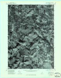
1979 Map of New Vineyard
USGS Topo · Published 1983About this map
New Vineyard Mountains dominate the central landscape of this 1979 orthophotoquad, showcasing the heavily forested and uneven terrain of Franklin County at the end of the decade. The aerial imagery provides a clear view of the dense canopy and winding watercourses, most notably Lemon Stream as it snakes through the northwestern corridor. Small clearings and homesteads are scattered throughout the hills, connected by a network of rural roads that link the primary settlements of New Vineyard and West Mills. This orthophotograph serves as a precise record of land use and vegetation patterns before later development, capturing the area's rural character during a period when small-scale timber and agriculture remained central to the local economy.
Find a feature on this map
4 named features on this map. Tap any name to fly to it.
Don’t see what you’re looking for? This feature index may not catch every label — zoom into the map to look around manually.
Map Details
Editions of this 1979 New Vineyard Map
This is the sole edition of this map. No revisions or reprints were ever made.
Other maps of this area

1894 · Norridgewock
USGS Topo · 1:62,500

1898 · Norridgewock
USGS Topo · 1:62,500

1904 · Anson
USGS Topo · 1:62,500

1924 · Farmington
USGS Topo · 1:62,500

1930 · Kingfield
USGS Topo · 1:48,000

1932 · Kingfield
USGS Topo · 1:62,500

1943 · Norridgewock
USGS Topo · 1:62,500

1948 · Bangor
USGS Topo · 1:250,000

1950 · Lewiston
USGS Topo · 1:250,000

1955 · Anson
USGS Topo · 1:62,500