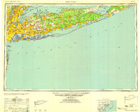
1958 Map of New York
USGS Topo · Published 1958About this map
Long Island serves as the central focus of this mid-century survey, capturing a pivotal moment of suburban expansion and industrial infrastructure. The postwar housing boom is evident in the development of Levittown, while the transportation network reflects the increasing dominance of the automobile with the Long Island Expressway and Southern State Parkway cutting across the landscape. Along the north shore, deep inlets like Oyster Bay and Smithtown Bay contrast with the long, continuous barrier beaches of the south shore, including Jones Beach and Fire Island Beach.
Find a feature on this map
86 named features on this map. Tap any name to fly to it.
Don’t see what you’re looking for? This feature index may not catch every label — zoom into the map to look around manually.
Map Details
Editions of this 1958 New York Map
3 editions found
Other maps of this area

1888 · Barnegat
USGS Topo · 1:62,500

1888 · Asbury Park
USGS Topo · 1:62,500

1888 · Paterson
USGS Topo · 1:62,500

1888 · Sandy Hook
USGS Topo · 1:62,500

1889 · Brooklyn
USGS Topo · 1:62,500

1891 · Ramapo
USGS Topo · 1:62,500

1891 · Brooklyn
USGS Topo · 1:62,500

1891 · Harlem
USGS Topo · 1:62,500

1891 · Bridgeport
USGS Topo · 1:62,500

1892 · Stamford
USGS Topo · 1:62,500