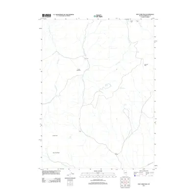
2011 Map of New York Peak
USGS Topo · Published 2011About this map
New York Peak towers over a landscape defined by isolated camps and critical water sources in this high-desert portion of the Black Rock Range. The presence of McCully Cabin and seasonal hubs like Cove Camp and Pearl Camp suggests a history of ranching or prospecting, where survival depended on a network of named water features including Josie Pearl Spring, Willow Spring, and Trough Spring. This 2011 survey captures the area’s rugged interior character, where landmarks such as Rodeo Flat and Cove Meadows provide the only level relief amidst the complex drainage systems of Corral Creek and Craine Creek. The southern boundary is marked by Bartlett Peak and the passage of Leonard Creek Rd, the primary route through this remote terrain. The naming of Trail Canyon and various family-named springs reflects the enduring legacy of early settlers and seasonal residents who navigated this challenging Nevada environment.
Find a feature on this map
21 named features on this map. Tap any name to fly to it.
Don’t see what you’re looking for? This feature index may not catch every label — zoom into the map to look around manually.
Map Details
Editions of this 2011 New York Peak Map
This is the sole edition of this map. No revisions or reprints were ever made.
Other maps of this area

1886 · Disaster
USGS Topo · 1:250,000

1893 · Disaster
USGS Topo · 1:250,000

1954 · Vya
USGS Topo · 1:250,000

1958 · Vya
USGS Topo · 1:250,000

1962 · Vya
USGS Topo · 1:250,000

1965 · Idaho Canyon
USGS Topo · 1:62,500

1965 · Duffer Peak
USGS Topo · 1:62,500

1972 · Burnt Springs
USGS Topo · 1:24,000

1972 · Leonard Cr. Slough North
USGS Topo · 1:24,000
1972 · Battle Creek Ranch
USGS Topo · 1:24,000