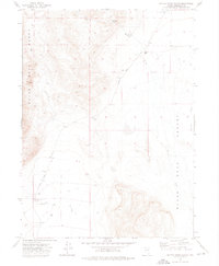
1972 Map of Battle Creek Ranch
USGS Topo · Published 1976About this map
Varyville marks a vanished settlement site in the high desert of Humboldt County, positioned at the edge of the Black Rock Range. In the early 1970s, this landscape remained dominated by isolated ranching operations and the vestiges of early mineral exploration. The transition from the steep terrain of Rough Canyon to the wide expanse of the Black Rock Desert is defined by several seasonal watercourses, including Bartlett Creek and Leonard Creek, which provided essential resources for the Clarkfield Ranch and Battle Creek Ranch.
Find a feature on this map
17 named features on this map. Tap any name to fly to it.
Don’t see what you’re looking for? This feature index may not catch every label — zoom into the map to look around manually.
Map Details
Editions of this 1972 Battle Creek Ranch Map
2 editions found
Other maps of this area

1886 · Disaster
USGS Topo · 1:250,000

1893 · Disaster
USGS Topo · 1:250,000

1954 · Vya
USGS Topo · 1:250,000

1958 · Vya
USGS Topo · 1:250,000

1962 · Vya
USGS Topo · 1:250,000

1965 · Idaho Canyon
USGS Topo · 1:62,500

1965 · Duffer Peak
USGS Topo · 1:62,500

1972 · Pinto Mountain
USGS Topo · 1:24,000

1972 · Burnt Springs
USGS Topo · 1:24,000

1972 · Leonard Cr. Slough North
USGS Topo · 1:24,000