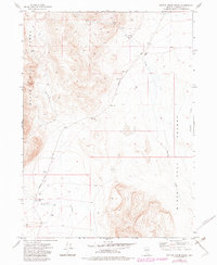
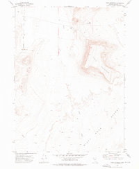
1972 Map of Battle Creek Ranch
USGS Topo · Published 1982About this map
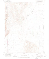
Varyville marks a point of historic interest where the Black Rock Range meets the edge of the Black Rock Desert in this high-desert landscape. The transition from the steep, carved terrain of Rough Canyon to the wide basin floor highlights the placement of early ranching outposts like Battle Creek Ranch and Clarkfield Ranch, which were established near vital water sources such as Battle Creek and House Spring. The presence of several wells and the seasonal flows of Bartlett Creek and Leonard Creek underscore the importance of water management for survival in this arid environment. Traces of human activity are further evidenced by a system of primitive roads and trails connecting these isolated settlements and resource points, including a Borrow Pit and the small station at Graves.
Find a feature on this map
17 named features on this map. Tap any name to fly to it.
Don’t see what you’re looking for? This feature index may not catch every label — zoom into the map to look around manually.
Map Details
Editions of this 1972 Battle Creek Ranch Map
2 editions found
Other maps of this area

1886 · Disaster
USGS Topo · 1:250,000

1893 · Disaster
USGS Topo · 1:250,000

1954 · Vya
USGS Topo · 1:250,000

1958 · Vya
USGS Topo · 1:250,000

1962 · Vya
USGS Topo · 1:250,000
1965 · Idaho Canyon
USGS Topo · 1:62,500
1965 · Duffer Peak
USGS Topo · 1:62,500
1972 · Pinto Mountain
USGS Topo · 1:24,000
1972 · Burnt Springs
USGS Topo · 1:24,000
1972 · Leonard Cr. Slough North
USGS Topo · 1:24,000