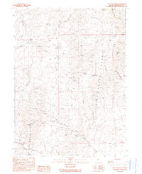
1990 Map of New York Peak
USGS Topo · Published 1990About this map
New York Peak stands as the centerpiece of this high-altitude landscape where the Pine Forest Range and Black Rock Range converge. This 1990 provisional survey documents a region defined by remote mining operations and seasonal water sources. Evidence of the area's mineral prospects is found at the Bartlett Mine, Juanita Mine, and Columbia Mine, while small outposts like Cove Camp and Pearl Camp provided base locations for high-desert activity. The terrain is deeply carved by drainage systems including New York Canyon and Pearl Canyon. Local topography is punctuated by numerous named water sources essential for survival in this environment, such as Josie Pearl Spring, Trough Spring, and Lone Meadow Spring, which supported movement through Cove Meadows and across Rodeo Flat.
Find a feature on this map
27 named features on this map. Tap any name to fly to it.
Don’t see what you’re looking for? This feature index may not catch every label — zoom into the map to look around manually.
Map Details
Editions of this 1990 New York Peak Map
This is the sole edition of this map. No revisions or reprints were ever made.
Other maps of this area

1886 · Disaster
USGS Topo · 1:250,000

1893 · Disaster
USGS Topo · 1:250,000

1954 · Vya
USGS Topo · 1:250,000

1958 · Vya
USGS Topo · 1:250,000

1962 · Vya
USGS Topo · 1:250,000

1965 · Idaho Canyon
USGS Topo · 1:62,500

1965 · Duffer Peak
USGS Topo · 1:62,500

1972 · Burnt Springs
USGS Topo · 1:24,000

1972 · Leonard Cr. Slough North
USGS Topo · 1:24,000
1972 · Battle Creek Ranch
USGS Topo · 1:24,000