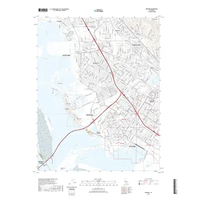
2018 Map of Newark
USGS Topo · Published 2018About this map
Newark and Fremont occupy a landscape defined by the expansive marshlands and sloughs of the southern San Francisco Bay. The eastern portion of the sheet is densely suburbanized, encompassing the Centerville District and neighborhoods such as Union City and Hayward. In contrast, the western margins remain dominated by the tidal geography of Newark Slough and Coyote Hills Slough, with the distinctive rising terrain of the Coyote Hills and Red Hill Top providing a natural break in the bayfront flats. Genealogy and local history researchers will find several significant burial grounds, including the Holy Ghost Cemetery and Presbyterian Cemetery. Infrastructure and industrial heritage are also prominent, featuring the Hetch Hetchy Aqueduct and the historical railroad siding at Hall Station. The network of trails, such as the Alameda Creek Trail and Crandall Creek Trail, illustrates the modern conversion of water-management corridors into public recreational spaces along the Alameda Creek delta.
Find a feature on this map
67 named features on this map. Tap any name to fly to it.
Don’t see what you’re looking for? This feature index may not catch every label — zoom into the map to look around manually.
Map Details
Editions of this 2018 Newark Map
This is the sole edition of this map. No revisions or reprints were ever made.
Other maps of this area

1889 · San Jose
USGS Topo · 1:62,500

1897 · San Jose
USGS Topo · 1:62,500

1897 · Palo Alto
USGS Topo · 1:62,500

1899 · San Jose
USGS Topo · 1:62,500

1899 · Palo Alto
USGS Topo · 1:62,500

1899 · Haywards
USGS Topo · 1:62,500

1902 · Santa Cruz
USGS Topo · 1:125,000

1906 · Pleasanton
USGS Topo · 1:62,500

1915 · Haywards
USGS Topo · 1:62,500

1941 · Pleasanton
USGS Topo · 1:62,500