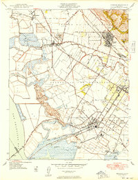
1948 Map of Newark
USGS Topo · Published 1948About this map
The salt marshes and industrial landings of the East Bay shoreline define this 1947 study, capturing a period of transition for southern Alameda County. Industry is heavily represented by the Sugar Refinery at Alvarado and multiple Salt Refinery sites along the San Francisco Bay margin. The landscape is a mix of reclaimed marshland and agricultural tracts, notably the Patterson Ranch and the historical Potrero de los Cerritos land grant area.
Find a feature on this map
57 named features on this map. Tap any name to fly to it.
Don’t see what you’re looking for? This feature index may not catch every label — zoom into the map to look around manually.
Map Details
Editions of this 1948 Newark Map
This is the sole edition of this map. No revisions or reprints were ever made.
Other maps of this area

1889 · San Jose
USGS Topo · 1:62,500

1897 · San Jose
USGS Topo · 1:62,500

1897 · Palo Alto
USGS Topo · 1:62,500

1899 · San Jose
USGS Topo · 1:62,500

1899 · Palo Alto
USGS Topo · 1:62,500

1899 · Haywards
USGS Topo · 1:62,500

1902 · Santa Cruz
USGS Topo · 1:125,000

1906 · Pleasanton
USGS Topo · 1:62,500

1915 · Haywards
USGS Topo · 1:62,500

1941 · Pleasanton
USGS Topo · 1:62,500