1956 Map of Newark
USGS Topo · Published 1956About this map
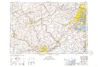
Industrial corridors and rail networks define the Mid-Atlantic landscape in this mid-century survey, stretching from the coal regions of Hazelton down to the urban density of Philadelphia. The map captures the complex infrastructure of the Delaware River valley, where major hubs like Easton, Bethlehem, and Allentown serve as vital nodes for the Lehigh Valley RR and Reading RR. This period represents the height of the regional railroad economy before the full expansion of the interstate system, with lines of the Pennsylvania RR and Central RR of New Jersey lacing together manufacturing centers such as Trenton and New Brunswick. Along the coast, the maritime and industrial interface of Staten Island, Perth Amboy, and Newark highlights the dense development surrounding Raritan Bay and the approach to Lower New York Bay.
Find a feature on this map
112 named features on this map. Tap any name to fly to it.
Don’t see what you’re looking for? This feature index may not catch every label — zoom into the map to look around manually.
Map Details
Editions of this 1956 Newark Map
2 editions found

Other maps of this area

1884 · Whitings
USGS Topo · 1:62,500

1888 · Franklin
USGS Topo · 1:62,500

1888 · Plainfield
USGS Topo · 1:62,500

1888 · Bordentown
USGS Topo · 1:62,500

1888 · Pemberton
USGS Topo · 1:62,500

1888 · Barnegat
USGS Topo · 1:62,500

1888 · Morristown
USGS Topo · 1:62,500

1888 · Hackettstown
USGS Topo · 1:62,500

1888 · New Brunswick
USGS Topo · 1:62,500

1888 · Mount Holly
USGS Topo · 1:62,500