
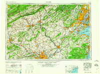
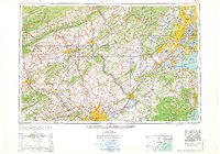
1960 Map of Newark
USGS Topo · Published 1960About this map
The Delaware River serves as the central artery for this industrial corridor, connecting the metropolitan hubs of Philadelphia and Trenton before winding northward past Easton. This mid-century survey illustrates the dense development of the Mid-Atlantic at a point when rail lines like the Pennsylvania RR and Reading RR still shared the landscape with an expanding network of U.S. highways. To the east, the heavy urbanization of Newark, Elizabeth, and Paterson reflects the post-war industrial peak of northern New Jersey, while the coast is marked by military installations such as Fort Hancock on Sandy Hook.
Find a feature on this map
166 named features on this map. Tap any name to fly to it.
Don’t see what you’re looking for? This feature index may not catch every label — zoom into the map to look around manually.
Map Details
Editions of this 1960 Newark Map
3 editions found
Other maps of this area

1884 · Whitings
USGS Topo · 1:62,500

1888 · Franklin
USGS Topo · 1:62,500

1888 · Plainfield
USGS Topo · 1:62,500

1888 · Bordentown
USGS Topo · 1:62,500

1888 · Pemberton
USGS Topo · 1:62,500

1888 · Barnegat
USGS Topo · 1:62,500

1888 · Morristown
USGS Topo · 1:62,500

1888 · Hackettstown
USGS Topo · 1:62,500

1888 · New Brunswick
USGS Topo · 1:62,500

1888 · Mount Holly
USGS Topo · 1:62,500