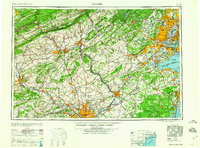
1960 Map of Newark
USGS Topo · Published 1960About this map
The industrial corridor of the Mid-Atlantic reaches its mid-century peak on this sheet, anchored by the massive urban hubs of Newark and Philadelphia. The Delaware River serves as the central artery for commerce and navigation, passing through Trenton and flowing toward the maritime complexes of Philadelphia. Along the coast, the geography of the New York Harbor is clearly defined, featuring Staten Island, Governors Island, and the recreational shoreline at Coney Island. The map captures the significant military presence of the era, from Fort Dix Military Reservation to Fort Hancock on Sandy Hook.
Find a feature on this map
325 named features on this map. Tap any name to fly to it.
Don’t see what you’re looking for? This feature index may not catch every label — zoom into the map to look around manually.
Map Details
Editions of this 1960 Newark Map
3 editions found

Other maps of this area

1884 · Whitings
USGS Topo · 1:62,500

1888 · Franklin
USGS Topo · 1:62,500

1888 · Plainfield
USGS Topo · 1:62,500

1888 · Bordentown
USGS Topo · 1:62,500

1888 · Pemberton
USGS Topo · 1:62,500

1888 · Barnegat
USGS Topo · 1:62,500

1888 · Morristown
USGS Topo · 1:62,500

1888 · Hackettstown
USGS Topo · 1:62,500

1888 · New Brunswick
USGS Topo · 1:62,500

1888 · Mount Holly
USGS Topo · 1:62,500