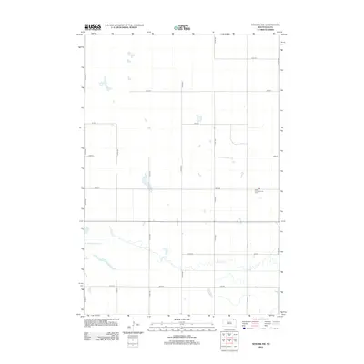
2012 Map of Newark SW
USGS Topo · Published 2012About this map
Renzienhausen Slough dominates the low-lying hydrology of this South Dakota landscape, where the meandering course of Crow Cr cuts through the prairie. The map depicts a highly structured grid of section-line roads, such as 111th St and 414th Ave, which define the agricultural development of the region. A primary point of community and commercial activity is the Sunset Farmers Co-op Colony, situated in the eastern portion of the survey area near 417th Ave. This layout illustrates a common pattern of Great Plains land use, where centralized cooperative colonies manage wide expanses of territory. The numerous small, scattered wetlands and basins across the quadrangle highlight the glaciated nature of the terrain, influencing the placement of local thoroughfares like 105th St and 109th St.
Find a feature on this map
17 named features on this map. Tap any name to fly to it.
Don’t see what you’re looking for? This feature index may not catch every label — zoom into the map to look around manually.
Map Details
Editions of this 2012 Newark SW Map
This is the sole edition of this map. No revisions or reprints were ever made.
Other maps of this area

1894 · Hecla
USGS Topo · 1:62,500

1896 · Columbia
USGS Topo · 1:125,000

1953 · Hecla SE
USGS Topo · 1:24,000

1953 · Newark SW
USGS Topo · 1:24,000

1953 · Newark
USGS Topo · 1:24,000

1953 · Milbank
USGS Topo · 1:250,000

1954 · Aberdeen
USGS Topo · 1:250,000

1956 · Aberdeen
USGS Topo · 1:250,000

1956 · Britton West
USGS Topo · 1:24,000
1956 · Claremont
USGS Topo · 1:24,000
Featured Places
- Portage Township, SD
- Sunset Hutterite Colony, SD
- North Detroit Township, SD
- South Detroit Township, SD
- Brown County, SD