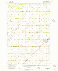
1956 Map of Claremont
USGS Topo · Published 1957About this map
The town of Claremont serves as the primary hub of this mid-century survey in Brown County, positioned along the Great Northern railroad. The surrounding landscape is defined by the expansive townships of Shelby, Detroit, Columbia, and Claremont, reflecting the organized agricultural layout of the Missouri River Basin development era. A series of water management and irrigation features are visible, most notably the Crow Creek Drainage Ditch and several instances of a Flowing Well, indicating the importance of groundwater in this prairie environment.
Find a feature on this map
11 named features on this map. Tap any name to fly to it.
Don’t see what you’re looking for? This feature index may not catch every label — zoom into the map to look around manually.
Map Details
Editions of this 1956 Claremont Map
2 editions found
Other maps of this area

1894 · Hecla
USGS Topo · 1:62,500

1896 · Columbia
USGS Topo · 1:125,000

1952 · Huffton
USGS Topo · 1:24,000

1952 · Putney
USGS Topo · 1:24,000

1953 · Hecla SE
USGS Topo · 1:24,000

1953 · Houghton
USGS Topo · 1:24,000

1953 · Newark SW
USGS Topo · 1:24,000

1953 · Milbank
USGS Topo · 1:250,000

1954 · Daly Corners
USGS Topo · 1:24,000

1954 · Aberdeen
USGS Topo · 1:250,000
Featured Places
- Claremont, SD
- South Detroit Township, SD
- Shelby Township, SD
- Columbia Township, SD
- Claremont Township, SD