
1952 Map of Huffton
USGS Topo · Published 1954About this map
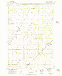
The Great Northern railroad cuts diagonally across the prairie landscape of Brown County, serving the small settlement of Huffton during the early 1950s. This survey, conducted as part of the Department of the Interior's Missouri River Basin development program, reveals a transition in rural education and social infrastructure. While active country schools like Featherhoff Sch, Happy Hour Sch, and Progress Sch dot the township boundaries of Claremont and Riverside, the map specifically notes the Washington Sch (Abandoned) in Putney township, signaling the shifting population patterns of the era. The presence of the Good Samaritan Home and several locations marked as Flowing Well highlights the community's reliance on groundwater and local care facilities in this northern Great Plains region.
Find a feature on this map
12 named features on this map. Tap any name to fly to it.
Don’t see what you’re looking for? This feature index may not catch every label — zoom into the map to look around manually.
Map Details
Editions of this 1952 Huffton Map
This is the sole edition of this map. No revisions or reprints were ever made.
Other maps of this area

1895 · Aberdeen
USGS Topo · 1:125,000

1896 · Columbia
USGS Topo · 1:125,000

1952 · Putney
USGS Topo · 1:24,000

1953 · Milbank
USGS Topo · 1:250,000

1954 · Groton
USGS Topo · 1:24,000

1954 · James
USGS Topo · 1:24,000

1954 · Daly Corners
USGS Topo · 1:24,000

1954 · Aberdeen
USGS Topo · 1:250,000

1956 · Aberdeen
USGS Topo · 1:250,000
1956 · Claremont
USGS Topo · 1:24,000