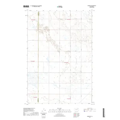
2017 Map of Newark SW
USGS Topo · Published 2017About this map
Brown Co Marshall Co defines the central axis of this landscape, marking the political divide between these two South Dakota counties. The terrain is characterized by a high density of wetlands and small basins typical of the Glacial Lake Agassiz region, with Crow Cr meandering through the southern sections. This 2017 survey reflects a sparsely populated agricultural environment organized by a strict grid of section lines and gravel roads, including Co Hwy 11 and 110th St. The absence of named towns within these specific coordinates highlights the rural character of the township, where the land is primarily used for seasonal water management and farming. Genealogists and local historians can use the precise Public Land Survey System (PLSS) markers, such as those in t127n r59w, to locate specific family homesteads or historic land allotments within this expansive prairie landscape.
Find a feature on this map
19 named features on this map. Tap any name to fly to it.
Don’t see what you’re looking for? This feature index may not catch every label — zoom into the map to look around manually.
Map Details
Editions of this 2017 Newark SW Map
This is the sole edition of this map. No revisions or reprints were ever made.
Other maps of this area

1894 · Hecla
USGS Topo · 1:62,500

1896 · Columbia
USGS Topo · 1:125,000

1953 · Hecla SE
USGS Topo · 1:24,000

1953 · Newark SW
USGS Topo · 1:24,000

1953 · Newark
USGS Topo · 1:24,000

1953 · Milbank
USGS Topo · 1:250,000

1954 · Aberdeen
USGS Topo · 1:250,000

1956 · Aberdeen
USGS Topo · 1:250,000

1956 · Britton West
USGS Topo · 1:24,000
1956 · Claremont
USGS Topo · 1:24,000
Featured Places
- Portage Township, SD
- Sunset Hutterite Colony, SD
- North Detroit Township, SD
- South Detroit Township, SD
- Brown County, SD