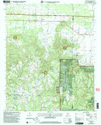
2000 Map of Newburg
USGS Topo · Published 2003About this map
The settlement of Newburg serves as a central point in this late-twentieth-century study of the borderlands between Franklin and Lawrence Counties. The landscape is defined by the expansive William B Bankhead National Forest and the Black Warrior Wildlife Management Area, where steep terrain like Macedonia Mountain and Eckerberger Mountain transitions into the fertile Tennessee Valley Area. A dense network of community landmarks provides significant value for local history research, including numerous country churches such as Sylvester Ch and Gray Rock Ch, alongside family-named burial grounds like Kimbrough Cem and Templeton Cem. Evidence of the region's industrial footprint is visible at the Strip Mine near Denton Hollow, while winding waterways like Mud Creek and Troublesome Creek dictate the rural road patterns of Russellville Road and Moulton Road.
Find a feature on this map
43 named features on this map. Tap any name to fly to it.
Don’t see what you’re looking for? This feature index may not catch every label — zoom into the map to look around manually.
Map Details
Editions of this 2000 Newburg Map
This is the sole edition of this map. No revisions or reprints were ever made.
Other maps of this area

1924 · Tuscumbia
USGS Topo · 1:48,000

1926 · Tuscumbia
USGS Topo · 1:62,500

1936 · Russellville
USGS Topo · 1:24,000

1936 · Newburg
USGS Topo · 1:24,000

1936 · Kinlock Spring
USGS Topo · 1:24,000

1936 · Phil Campbell
USGS Topo · 1:24,000

1936 · Moulton
USGS Topo · 1:48,000

1936 · Spruce Pine
USGS Topo · 1:24,000

1936 · Hatton
USGS Topo · 1:24,000

1936 · Landersville
USGS Topo · 1:24,000