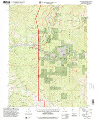
1995 Map of Newhouse Ridge
USGS Topo · Published 2001About this map
The Middle Fork Eel River and Black Butte River converge in this high-altitude landscape within the Mendocino National Forest. The 1995 revision reveals a rugged terrain dominated by prominent formations like Anthony Peak, Nebo Rock, and the extensive New House Ridge. Human activity is concentrated along the river valleys and ridge-top routes, most notably at the Eel River Work Center and the remote Bauer Ranch. The network of forestry roads and 4WD tracks, including the Mendocino Pass Road, highlights the area's importance for timber management and backcountry access. Local family history is preserved in names like George Lambert Canyon and the Capistran Ranch, while the numerous springs and wells indicate the critical water management required in these steep northern California basins.
Find a feature on this map
51 named features on this map. Tap any name to fly to it.
Don’t see what you’re looking for? This feature index may not catch every label — zoom into the map to look around manually.
Map Details
Editions of this 1995 Newhouse Ridge Map
This is the sole edition of this map. No revisions or reprints were ever made.
Other maps of this area

1926 · Covelo
USGS Topo · 1:62,500

1929 · Eden Valley
USGS Topo · 1:62,500

1952 · Hull Mountain
USGS Topo · 1:62,500

1952 · Eden Valley
USGS Topo · 1:62,500

1952 · Covelo
USGS Topo · 1:62,500

1952 · Anthony Peak
USGS Topo · 1:62,500

1957 · Ukiah
USGS Topo · 1:250,000

1960 · Ukiah
USGS Topo · 1:250,000
1966 · Leech Lake Mountain
USGS Topo · 1:24,000

1967 · Plaskett Ridge
USGS Topo · 1:24,000