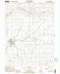
1998 Map of Newman
USGS Topo · Published 2002About this map
Newman stands as the primary hub of this eastern Illinois landscape, situated along the Brushy Fork in Douglas County. The late twentieth-century layout of the town is detailed through a grid including Vanderen St, Green St, and Shute St, surrounding the central Memorial Park. The surrounding countryside is defined by agricultural drainages and small rural settlements like McCown, Hume, and Palermo, each connected by a network of local roads and watercourses such as Pope Branch and Gilkey Branch.
Find a feature on this map
30 named features on this map. Tap any name to fly to it.
Don’t see what you’re looking for? This feature index may not catch every label — zoom into the map to look around manually.
Map Details
Editions of this 1998 Newman Map
This is the sole edition of this map. No revisions or reprints were ever made.
Other maps of this area

1936 · Oakland
USGS Topo · 1:48,000

1942 · Oakland
USGS Topo · 1:62,500

1946 · Kansas
USGS Topo · 1:62,500

1949 · Kansas
USGS Topo · 1:62,500

1953 · Indianapolis
USGS Topo · 1:250,000

1956 · Indianapolis
USGS Topo · 1:250,000

1956 · Newman
USGS Topo · 1:62,500

1956 · Villa Grove
USGS Topo · 1:62,500

1957 · Indianapolis
USGS Topo · 1:250,000

1958 · Decatur
USGS Topo · 1:250,000