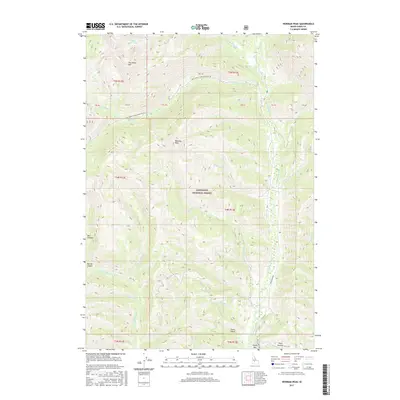
2017 Map of Newman Peak
USGS Topo · Published 2017About this map
Sawtooth National Forest dominates this Idaho landscape, where the S Fork Boise River cuts through the high elevation of Camas County. The terrain is defined by dramatic peaks and deep drainages, including Newman Peak and Two Point Mtn, which overlook a complex network of seasonal and perennial streams. To the south, the river passes Jones Bar, a low-lying area near the confluence of several tributaries such as Skeleton Cr and Fleck Summit. The mapping of US Forest Service lands here shows the essential access routes for the era, specifically the Natl Forest Develop Road 80 Rd and the Boise River Rd, which follow the natural contours of the river valleys. This 2017 survey provides a detailed view of the watershed, tracing numerous named forks including E Fork Skeleton Cr and W Fork Skeleton Cr.
Find a feature on this map
44 named features on this map. Tap any name to fly to it.
Don’t see what you’re looking for? This feature index may not catch every label — zoom into the map to look around manually.
Map Details
Editions of this 2017 Newman Peak Map
This is the sole edition of this map. No revisions or reprints were ever made.
Other maps of this area

1894 · Rocky Bar
USGS Topo · 1:125,000

1900 · Sawtooth
USGS Topo · 1:125,000

1955 · Hailey
USGS Topo · 1:250,000

1959 · Hailey
USGS Topo · 1:250,000

1962 · Hailey
USGS Topo · 1:250,000

1964 · Frenchman Creek
USGS Topo · 1:24,000

1964 · Ross Peak
USGS Topo · 1:24,000
1964 · Jumbo Mtn
USGS Topo · 1:24,000

1964 · Marshall Peak
USGS Topo · 1:24,000

1970 · Sydney Butte
USGS Topo · 1:24,000